Smart Rainfall System
Smart Rainfall System (SRS) is our disruptive solution for estimating and pinpointing rainfall in real-time and providing short-term forecasts of hydrogeological risk.
SRS creates real-time, high-definition rainfall maps, taking advantage of a well-known telecommunications phenomenon: the attenuation of electromagnetic waves in the case of precipitation. By analysing the satellite TV signal received by a distributed network of commercial parabolic dishes, SRS defines maps of rainfall intensity that can be used to check whether critical rainfall levels have been exceeded in the monitored areas.
Thanks to this information and applying a semi-distributed continuous hydrological model, SRS is able to predict the consequences of rainfall.
SRS is sustainable and innovative tool for an improved regional management and a better response to hydrogeological emergencies.
IN-HERITAGE
IN-HERITAGE is the decision support and knowledge sharing platform that collects and gives access to up-to-date information on conservation status of
architectural heritage with respect to environmental factors through «digital twin».
IN-HERITAGE aims to monitor the state of conservation of historical
buildings through a sustainable, non-invasive and replicable technology
and meets the need to improve the management of cultural heritage
thanks to the knowledge and continuous control of degradation and
its main triggers (pollution and climate conditions), also as a result
of climate change.
The platform provides comprehensive information on the environmental
situation of the site obtained using satellite data and an up-to-date
mapping of facade degradation through geometric (with laser scanner),
photographic and photothermal (with suitably equipped drones). It is also
possible to track the evolution of the conservation over time by correlating it with environmental and atmospheric variables.
The solution has been piloted since December 2022 on the Unesco site of the Palazzi dei Rolli in Genoa, affecting the facades of Palazzo Tursi, Palazzo
Reale and Palazzo Spinola di Pellicceria.
Aura
AURA is the innovative global service that combines SRS with air quality sensors to access real-time data and information on weather conditions to strengthen environmental sustainability policies.
AURA, through a wide range of measured parameters (NO2, NO, O3, PM10, PM2.5, PM1, SO2, CO, H2S and CO2, temperature, pressure and humidity, and environmental noise), is articulated to offer high monitoring performance and enable accurate analysis of the chemical composition of the atmosphere through the use of innovative context analysis systems.
The service supports local governments in measuring the environmental impacts and effectiveness of initiatives to reduce pollutant emissions in urbanized context and in incentivizing virtuous behaviors of citizens through information on the effects of their habits on air quality.
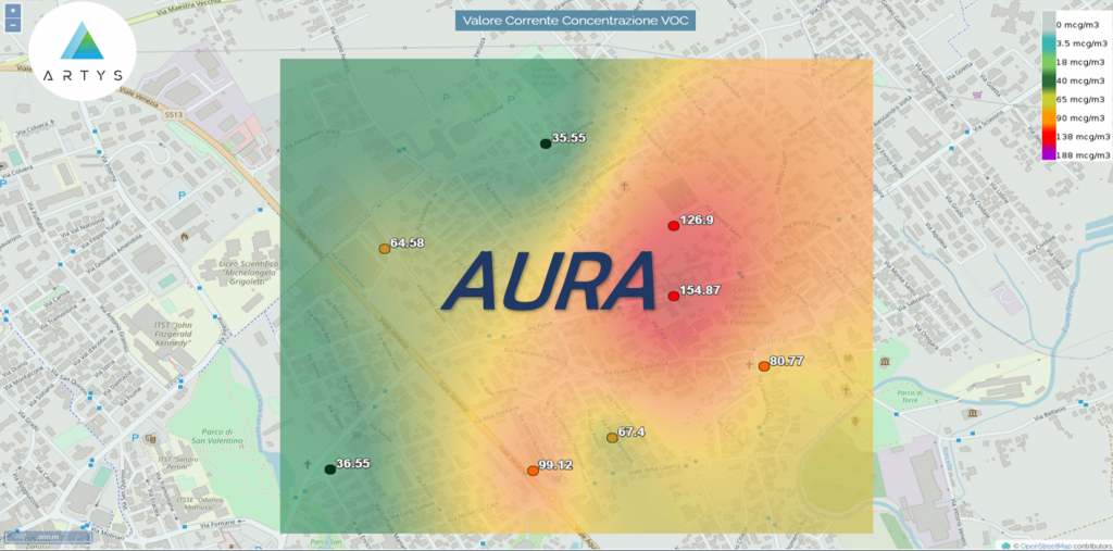
The cloud-based service for processing and representation of measurements provides 24/7 data through two main visualization systems: the web platform for citizen and the access dedicated to public authorities for use of data, graphical elaborations, periodic reports, and urban multimedia panel for the visualization of daily air quality index maps and their dissemination.